A video shot by drone is a more reliable, less costly, and safer solution. The Lee Sormea business unit and Citeos carried out one of the first airborne traffic studies.
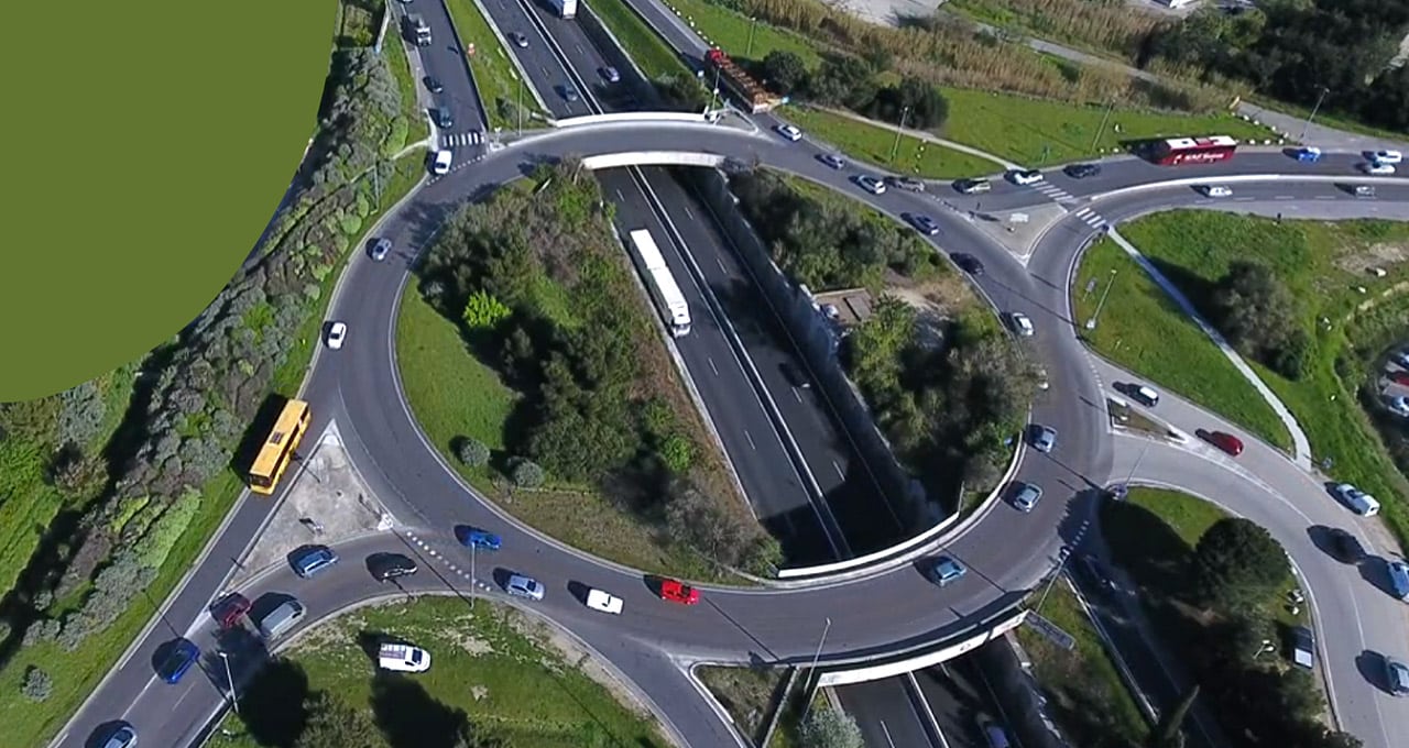
Why and how do traffic jams occur? How can traffic be better regulated? To answer these questions, a consulting firm will conventionally track the vehicles entering the critical area over a given period of time. This is done either by investigators reading the licence plates of vehicles entering and exiting the defined area to determine the route covered by comparing data, or by installing a video camera on a mast, gantry, or bridge to record footage that investigators then analyse. There are limits to both solutions: human error in the former, difficulty positioning cameras in some road configurations in the latter. Can new technologies offer a way to devise different solutions? The Lee Sormea business unit sought to find out in an experiment carried out in southern France. Faced with the need to shoot a wide-angle video at a chronically congested roundabout on the RN 113 in the city of Arles in southern France, the VINCI Energies business unit dedicated to traffic studies thought of using a camera on board a drone.
Lee Sormea carried out the experiment with Citeos, the VINCI Energies brand specialising in lighting and dynamic urban equipment, which already had experience using the airborne technology since it is regularly called on to provide a “bird’s eye view”.
To investigate 30-metre stadium lighting poles or to show elected officials the area covered by a planned video surveillance camera, the company used costly lift platforms. Then it invested in a drone equipped with a camera and in training a technician for four weeks, who received a drone pilot licence.
Overview
“This first experiment was conclusive in terms of costs, reliability of the information collected, and safety of personnel who would otherwise have had to work under difficult conditions on this road intersection,” says Lee Sormea project manager Matthieu Gondran.
“This method gives the customer highly informative images in addition to figures and analysis.”
An analysis of the images taken by the drone provided an overview of the roundabout, both in quantitative (number of vehicles) and qualitative terms. The video shows behaviour, routes taken on the roundabout and difficulties in merging with traffic – all this information making it possible to understand the cause of slowdowns. In addition, “This method gives the customer highly informative images in addition to figures and analysis,” says Matthieu Gondran.
Artificial intelligence could be used to further perfect the tool. The Lee Sormea project manager mentions the possibility of automated processing of the images recorded by the drone. With or without onboard intelligence, the airborne camera has a bright future but nevertheless has limits. The use of drones on public thoroughfares is highly regulated and subject to authorisations that can take several weeks to be obtained, including authorisation by the Prefect, related to the definition of a strictly defined overflight area to ensure the safety of people on the ground, as well as authorisation in some cases (including Arles) by the French Air Force when the drone is to be used in the vicinity of an airfield. Last but not least, authorisation by the sky itself, since the drone must wait for favourable weather to begin operating.