Omexom Atlantique Ingénierie has developed a flexible and innovative method of producing accurate maps of built underground infrastructure for the benefit of operators of buried networks.
Under a network damage prevention reform introduced in France on 1 July 2012, operators of utility networks (electricity, gas, fibre, etc.) must be able to supply maps, as part of the French “declaration of intent to carry out works in proximity of services” procedure, with class A accuracy. This means that mapping must be accurate to the nearest 50cm for flexible structures and to the nearest 40cm for rigid structures.
Enacted in keeping with the Grenelle II Law on the environment, the legislation aims to reduce damage caused during works on gas pipelines, electric power cables, fibre cables and telecoms networks.
In practical terms, operators can choose between two methods. The first involves detecting existing networks either with non-intrusive techniques – sound intensity probe, ground-penetrating radar, electromagnetic detection – or destructively using boreholes.
The second, which involves geo-referencing new or existing assets, associates a wealth of data accurately repositioned in space with a topographical point.
However, this method has one constraint, explains Sylvain Pejean, business manager at Omexom Atlantique Ingénierie: “Since network operators are resistant to ducting detection being carried out once trenches have been closed, geo-referencing must be performed on open trenches. But it’s difficult to send a certified land surveyor plus their equipment to each site to undertake measurements before the backfilling.”
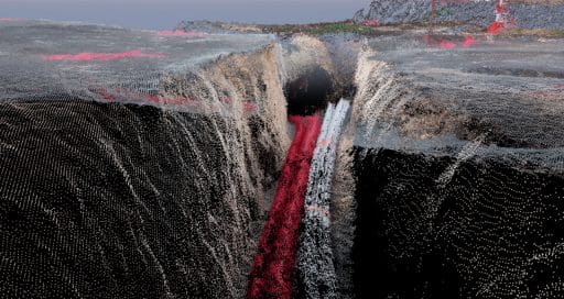
Photogrammetry and parallax
That’s where the Triptop method developed by Omexom Atlantique Ingénierie comes in. Triptop is a French acronym that stands for smart and accurate photogrammetry-based survey technique for open trenches, and it involves geo-referencing buried networks by means of photogrammetry. Measurements are performed in a defined area by using the parallax in images acquired with different view angles.
“A technique that delivers accurate measurements, simple implementation, a low operating cost, operator safety and a reduction in CO2 emissions.”
“We wanted to provide our clients with a technique that delivers accurate measurements, simple implementation, a low operating cost, operator safety and a reduction in CO2 emissions,” says Pejean.
Pole and GoPro
“The method means our surveyors don’t have to keep travelling back and forth between two worksites dozens of kilometres apart and that highly accurate as-built drawings can be produced,” points out Marc Juillard, manager of the Delaire Energies business unit.
The site manager positions reference points on the ground and numbers them as the project progresses. Using a 3m telescopic pole and a GoPro camera, he or she films the ducting, cables and reference points above the open trench. At the end of the project, the surveyor takes GPS readings of the survey points around all the structures and sends the video and GPS coordinates to Omexom Atlantique Ingénierie, which then links the data to produce a map with class A accuracy.
“Our surveyors now only need to make one or two visits to each worksite,” says Juillard.
18/02/2022