Omexom’s universal, rapid Nomad Mapping System technology is used to perform highly operational topographic surveys for companies.
Google and its Maps and Street View tools have given the public at large an understanding of the benefits of geolocation and visual display of our everyday environment. The same capabilities are game-changers for industrial undertakings and businesses increasingly keen to obtain extremely precise topographic data and 3D displays.
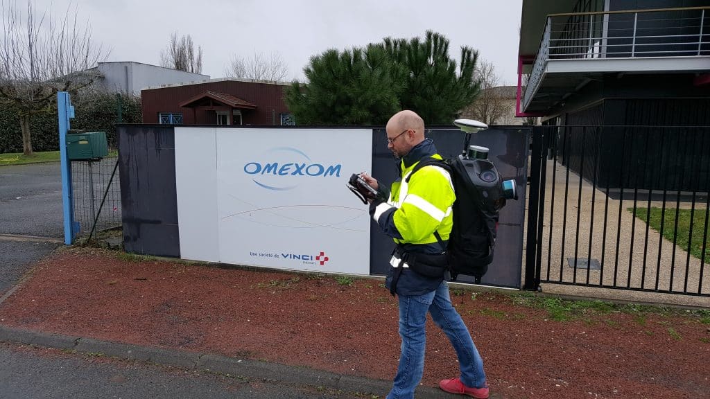
Lasers carrying out measurements from a helicopter or a car have to some extent replaced yesterday’s surveyors. A new technology provided by Omexom (VINCI Energies) called the Nomad Mapping System (NMS), is now, in turn, replacing cumbersome airborne solutions that cannot be used in such configurations building interiors.
Sylvain Pejean, a project manager at Omexom Atlantique Ingénierie, describes the combination of technologies that underpin the NMS: the system, contained in a backpack, comprises a GPS, an inertial unit (a navigation tool with a variety of precision sensors), two laser scanners and five video cameras.
Interfaced with a powerful computer, the tool can collect impressive amounts of data as the operator moves around the area to be mapped: every 125th of a second, five photos covering 180° and associated with a “point cloud” locating them within the area are added to the “technology gleaner’s” bag.
Because NMS is easy to use and can perform surveys inside buildings as well as outside, it can be used in a very wide variety of applications.
“By laying the point cloud over the photos, the NMS and associated computer reconstruct the path taken by the apparatus and deliver an extremely precise 3D survey that is far more comprehensive than a conventional survey and completed far faster,” says Sylvain Pejean.
Another advantage of the solution is the wealth of data collected, which make it possible to correct a survey after the fact. “If you ask a surveyor to survey the left-hand side of a road, and then you change your mind and decide to use the right-hand side instead, the surveyor has to start back from scratch; whereas the NMS data and photos give you all the information you need to make the change,” says the Omexom Atlantique Ingénierie project manager.
From BIM to industry
Because NMS is easy to use and can perform surveys inside buildings as well as outside, it can be used in a very wide variety of applications. Made available to the various VINCI Energies business activities, “it enables Actemium to offer its customers more efficient surveys in an industrial setting and VINCI Facilities to carry out even more detailed building information modelling in facilities it manages,” says Sylvain Pejean.
The NMS has already been used in optical fibre projects, both in cable laying operations and in determining where connection boxes should be installed on facades. Lastly, the Omexom tool is suitable for drawing up a 3D map of a movie theatre with very complex design, including the frame, inclined surfaces and stairs. In another example, NMS was used to map the 250 km of national highways in Guadeloupe, with a nod to Google Street View.
17/05/2018